The secret to understanding the Scottish Highlands isn’t just spotting glacial features, but learning to read the dynamic ‘dialogue’ between ancient ice and the underlying rock.
- Different rock types like granite and schist ‘remember’ glaciation differently, directly impacting everything from a scrambler’s grip to erosion patterns.
- The legacy of the Ice Age is not static; it actively shapes today’s landscape through slope instability, suppressed treelines, and the behaviour of perennial snow patches.
Recommendation: Start observing how glacial landforms have dictated human activity, from the strategic placement of castles on volcanic plugs to the composition of a landscape photograph.
To stand in a Scottish glen is to stand inside a masterpiece of natural engineering. The sheer scale of the landscape—the sweeping valleys, the jagged peaks, the deep, dark lochs—is immediately apparent. Most visitors can point out a U-shaped valley and correctly attribute it to the colossal power of glaciers. Yet, this is merely the opening chapter of a much deeper, more intricate story written across millions of years. It’s the difference between admiring a painting and understanding the artist’s every brushstroke, the texture of the canvas, and the chemistry of the pigments.
The common approach is to treat the landscape as a museum of static exhibits: “Here is a corrie,” “There is a moraine.” But to truly read the land as a geologist does, you must shift your perspective. The key is not to identify a checklist of features, but to understand the dynamic dialogue between ice and rock. The Ice Age wasn’t a monologue where glaciers simply bulldozed everything in their path. It was a complex interaction where the type of ice, its temperature, and its speed engaged with the specific strengths and weaknesses of the rock beneath. This conversation, frozen in time, dictates everything you see and touch today.
This guide moves beyond simple identification. We will explore how the ‘memory’ of the rock affects a climber’s safety, how the ‘ghost’ of the glacier still triggers landslides, and how ice acted as a master surgeon, carving away mountains to reveal their volcanic hearts. By the end, you will no longer see just a beautiful landscape; you will see a story of unimaginable forces, subtle vulnerabilities, and a geological legacy that continues to shape the wild heart of Scotland.
This article will guide you through the essential skills needed to interpret the glacial narrative etched into the Highlands. We will delve into the practicalities of rock textures, the warning signs of a changing landscape, and the geological secrets behind Scotland’s most iconic views.
Table of Contents: A Geologist’s Guide to the Scottish Landscape
- Granite vs Schist: Which Rock Offers Better Grip for Scrambling?
- The Warning Signs of Slope Instability After Heavy Rain
- Where to Find the Remains of Ancient Volcanoes in Glencoe?
- Why Do Trees Stop Growing at Certain Altitudes in Scotland?
- How Are Scottish Snow Patches Changing Over the Last 10 Years?
- Glencoe or Torridon: Which Offers Better Dramatic Landscapes for Beginners?
- Why Are Castles Built on Volcanic Plugs?
- How to Photograph Highland Peaks in Low Light Conditions Without Grain?
Granite vs Schist: Which Rock Offers Better Grip for Scrambling?
For a scrambler or hillwalker, the texture of rock underfoot is a matter of immediate concern. This texture is not random; it’s a direct result of the dialogue between the rock type and the glacial ice that passed over it. The two dominant rock types in the Highlands, granite and schist, have a profoundly different ‘memory’ of glaciation, which translates directly to the grip they offer. Granite, a hard, crystalline igneous rock found in the Cairngorms, tends to be smoothed and polished by glaciers. This process creates what are known as glacially-polished surfaces, which can be beautiful but treacherously slippery, especially when wet.
In contrast, the mica schists of the Western Highlands are metamorphic rocks with a distinct layered structure, or foliation. When a glacier plucked at this rock, it tended to break off along these layers, creating a jagged, stepped surface. These natural, rough-hewn steps provide excellent handholds and footholds. Therefore, while both are hard rocks, the glacially-plucked schist often offers a far more secure scrambling experience than polished granite. However, the story changes with altitude. On high granite tors like those on Bennachie, frost-shattering has created a coarse, grippy surface that was above the main polishing action of the ice sheets.
Understanding this fundamental difference is the first step in reading the landscape for safety and route-planning. The forces that shaped the grand vistas also created the micro-textures that determine your stability on a steep slope. As a case study from the Geological Society of London highlights, the schists of the Highlands, formed during the Caledonian mountain-building event, display characteristic foliation that creates these natural grip features. This contrasts starkly with the granite plutons of the Cairngorms, where glacial polishing dominates. The friction between you and the mountain is a direct legacy of this ancient geological conversation, and as some research on rock friction properties demonstrates, coefficients can vary dramatically depending on this exact surface roughness.
The Warning Signs of Slope Instability After Heavy Rain
The Ice Age may be over, but its ‘ghost’ continues to haunt the Scottish mountains in the form of slope instability. When the glaciers retreated, they left behind vast quantities of unconsolidated material—a chaotic mixture of clay, sand, gravel, and boulders known as glacial till or moraine. These deposits, often plastered high on valley sides, are inherently unstable. After periods of heavy rain, the water saturates this material, increasing its weight and lubricating the particles, dramatically raising the risk of debris flows and landslides.
Recognizing the warning signs of this instability is a critical skill for any nature lover venturing into the glens. This is not about predicting a catastrophic failure, but about developing a geologist’s eye for subtle changes in the landscape that signal potential danger. The land speaks a language of stress and movement, and you can learn to interpret it. Look for fresh tension cracks appearing on grassy slopes, or for bulging at the base of a steep bank of till. These are signs the material is beginning to deform and move under its own weight.
Pay close attention to water. Clear water seeping from the base of a moraine is usually a good sign of healthy drainage. However, if that water turns muddy, it indicates that fine material is being eroded from within the deposit, creating voids and weakening its internal structure. Similarly, a sudden drop in the flow of a stream below a slope could mean a blockage is forming upstream, a potential prelude to a sudden release. By learning to spot these signs, you are reading the active, and sometimes hazardous, legacy of the last glaciation.
Your Field Checklist for Glacial Deposit Instability
- Assess surface integrity: Systematically scan slopes for new cracks in glacial till deposits, as these indicate tension and potential failure zones.
- Monitor water seepage: Observe water emerging at the base of moraines. Differentiate between clear water (normal drainage) and muddy water (internal erosion).
- Track stream behaviour: Monitor changes in stream flow below glacial deposits. A sudden decrease or stoppage may indicate a dangerous blockage from debris.
- Check for structural deformation: Look for any bulging at the base of slopes, a classic indicator that rotational failure is beginning.
- Listen for auditory cues: In quiet corrie headwalls, especially after rain, listen for unusual sounds like cracking rock or the subtle rumble of stone movement.
Where to Find the Remains of Ancient Volcanoes in Glencoe?
Glencoe’s dramatic, almost intimidating, beauty is the direct result of a brutal partnership between fire and ice. The iconic peaks that tower over the glen, such as the Three Sisters, are not just random mountains; they are the skeletal remains of a colossal, 400-million-year-old volcano. For millennia, this volcanic heart was buried under layers of softer rock. It took the surgical precision of Ice Age glaciers to excavate it. A powerful, fast-flowing ice stream, funnelled down the valley, acted as a giant conveyor belt, scouring away billions of tons of weaker surrounding rock and exposing the hardened volcanic plugs and ring dykes at the volcano’s core.
To find these volcanic remains, you simply need to look up. The most dramatic peaks of Glencoe *are* the remains. The process of glacial erosion, detailed in a report by NatureScot on ice-carved landscapes, shows how ice streams were powerful enough to breach watersheds and cut entirely new glens, performing a large-scale geological dissection. The U-shaped valley floor you walk or drive along is the incision mark left by this immense surgical tool, while the towering peaks are the resistant bone and gristle of the ancient caldera that the ice could not remove.
This process of “differential erosion”—where hard rock is left standing while soft rock is carried away—is the fundamental principle behind Glencoe’s drama. The flat valley floor and the steep, soaring peaks are two sides of the same glacial coin. The ice didn’t just carve a valley; it exhumed a lost world of volcanic geology, putting it on full display.
As you can see, the light catches the hard, resistant volcanic ridges while the deep, glacially carved corries remain in shadow. This interplay of light and shadow tells the story of what the ice removed and what it was forced to leave behind.
This table summarises the transformation of Glencoe’s landscape by glacial action, revealing the volcanic structures that lie at its heart.
| Feature | Original Volcanic Form | Glacial Modification | Current Appearance |
|---|---|---|---|
| Three Sisters | Buried volcanic plugs | Exhumed by ice erosion | Dramatic peaked ridges |
| Valley Floor | High plateau | U-shaped glacial trough | Flat, accessible glen |
| Ring Dykes | Subsurface intrusions | Exposed by ice scouring | Visible circular patterns |
Why Do Trees Stop Growing at Certain Altitudes in Scotland?
As you climb a Scottish mountain, you’ll notice a distinct point where the forest gives way to open moorland of heather and grass. This is the natural treeline, and its strikingly low altitude in Scotland compared to other parts of the world is another lingering ghost of the Ice Age. The primary reason is not simply the cold or wind, but a more fundamental issue: the lack of soil. During the last glaciation, massive ice sheets acted like continental-scale sandpaper, scraping the mountains bare of the rich, deep soils that had developed over millennia.
This glacial scouring left behind a thin, acidic, and poorly-drained substrate that is inhospitable for most tree species. The glaciers effectively reset the ecological clock, and the thousands of years since have not been long enough to regenerate deep, fertile mountain soils. As geologist David Redfern eloquently states in his work on Scottish glacial landscapes:
Glaciers scraped the mountains bare, removing rich, ancient soils and leaving behind a thin, acidic, and poorly-drained substrate that can only support heather and grass at altitude
– David Redfern, Glacial landscapes in Scotland
Furthermore, the very tops of the highest mountains were, until relatively recently, under a near-glacial climate. A study analysing peat bog evidence revealed that Scotland’s climate has fluctuated significantly. As geological and historical evidence suggests, there may have been active glacial ice in the high corries of the Cairngorms as recently as the late 17th century during the “Little Ice Age”. The modern natural treeline is suppressed well below these elevations because the conditions required for glaciers to exist were present only a few hundred metres above Scotland’s highest summits. Trees simply couldn’t establish a foothold in areas that were, geologically speaking, only yesterday covered in or threatened by ice.
How Are Scottish Snow Patches Changing Over the Last 10 Years?
The persistent snow patches that cling to Scotland’s highest mountains, like the famous “Sphinx” in the Cairngorms, are more than just leftover winter snow. They are the embryos of glaciers, tiny echoes of the colossal ice sheets of the past. These patches survive in north-facing corries—the armchair-shaped hollows carved by ancient glaciers—precisely because these locations are sheltered from the sun and accumulate wind-blown snow. They are modern-day analogues for the very first stages of glaciation and are incredibly sensitive indicators of climate change.
Observing these snow patches is like watching a glacier in ultra-slow motion. The process of nivation, where the snow patch slowly deepens its hollow through repeated freeze-thaw cycles at its edges, is a micro-glacial process that is still active today. Over the last decade, observers have noted that these patches are shrinking and their number of survival days through the summer is decreasing, a direct response to warming temperatures. This mirrors the pattern of the last major glacial event in Scotland, the Loch Lomond Readvance around 12,000 years ago, where an ice cap and small corrie glaciers formed in these very same locations.
The fate of these snow patches is a bellwether for the future. They exist on a climatic knife-edge. Intriguingly, the same sensitivity that makes them vulnerable also highlights how close the Scottish climate is to one that could support glaciers once more. As some climate sensitivity research shows that a sustained temperature drop of just 1-2°C could be enough to cause glaciers to start forming again in the high corries. The changing state of these snow patches is not just a curiosity; it’s a real-time data point in the ongoing story of Scotland’s relationship with ice, connecting the deep past to the immediate future.
Glencoe or Torridon: Which Offers Better Dramatic Landscapes for Beginners?
For a beginner seeking to immerse themselves in Scotland’s glacial drama, the choice between Glencoe and Torridon presents two distinct but equally magnificent geological narratives. The “better” option depends entirely on the type of experience you seek. Glencoe offers immediate, theatrical immersion, while Torridon provides a sense of ancient scale and isolation. Their differences are rooted in the type of glaciation they endured.
Glencoe was carved by a fast-flowing ice river. This powerful, warm-based glacier was channelled down a pre-existing valley system, exploiting geological faults to gouge out a deep, classic U-shaped trough. The result is a landscape that feels like a stage set; you walk or drive directly onto the floor of the glacial trough, with the dramatic walls soaring on either side. The drama is accessible and in-your-face from the moment you arrive. This type of glaciation produced what geologist David Redfern describes as a classic “alpine landscape of peaks, troughs, cirques, aretes, screes, glacial breaches”.
Torridon, by contrast, tells a story of a slower, more expansive ice sheet. This vast body of ice scoured the entire landscape, stripping it down to the ancient bedrock but leaving the exceptionally hard Torridonian sandstone peaks standing as isolated giants or “island mountains.” The drama here is one of scale and earned views. The valleys are wider, and the sense of deep time is more profound as you look upon mountains that stood as islands in a sea of ice. The visual impact is less of a theatrical trough and more of a grand, minimalist panorama.
The following table breaks down the key differences for a beginner hiker or visitor, helping to illustrate the two different stories of ice.
| Feature | Glencoe | Torridon | Beginner Accessibility |
|---|---|---|---|
| Valley Type | Deep U-shaped glacial trough | Isolated peaks above scoured landscape | Glencoe: easier valley floor access |
| Glacial Process | Fast-flowing ice river | Slow-moving ice sheet | Different viewing perspectives |
| Rock Type | Volcanic, fault-exploited | Ancient Torridonian sandstone | Both offer stable scrambling |
| Drama Type | Walk-in theatrical valley | Earned summit views | Glencoe: immediate impact |
Why Are Castles Built on Volcanic Plugs?
The strategic placement of many of Scotland’s most famous castles, including those at Edinburgh and Stirling, is no accident of history. It is a masterclass in human ingenuity piggybacking on a geological process known as “crag and tail” formation. This is another facet of the dialogue between ice and rock, where glaciers inadvertently created the perfect natural fortifications. These castles are often built on volcanic plugs—extremely hard, resistant remnants of ancient volcanoes.
During the Ice Age, a massive ice sheet flowed over the landscape. When it encountered a tough volcanic plug, it was forced to flow around and over it. The “upstream” side of the plug (facing the ice flow) was scoured and steepened, creating a sheer, easily defensible cliff or ‘crag’. More importantly, the hard rock of the plug protected the softer material on its “downstream” side from erosion. The ice deposited a streamlined, gently sloping ramp of glacial till and other debris in this protected wake, forming the ‘tail’.
This created an ideal defensive position: a high, inaccessible crag for the main keep, connected to the surrounding land by a single, defensible ridge—the tail. As a prime example, an analysis of Edinburgh’s geology shows the Castle on its crag with the ‘tail’ forming the Royal Mile. The ice sheet carved away the softer surrounding rock, leaving the 340-foot volcanic plug as a commanding defensive position. Humans simply recognized and utilized this pre-made fortress. The next time you visit a Scottish castle, look for these features: the steep crag, the sloping tail, and the tell-tale signs of glacial polish or striations on any exposed bedrock at the foundations.
Key Takeaways
- Reading the landscape is a skill: It’s not about a checklist of features, but understanding the dynamic dialogue between ice and rock.
- The Ice Age’s legacy is active: Its effects are not just ancient history; they actively influence modern slope stability, treelines, and even climate indicators like snow patches.
- Glacial forms dictate human activity: The shapes carved by ice have determined everything from a climber’s grip and a castle’s location to the composition of a photograph.
How to Photograph Highland Peaks in Low Light Conditions Without Grain?
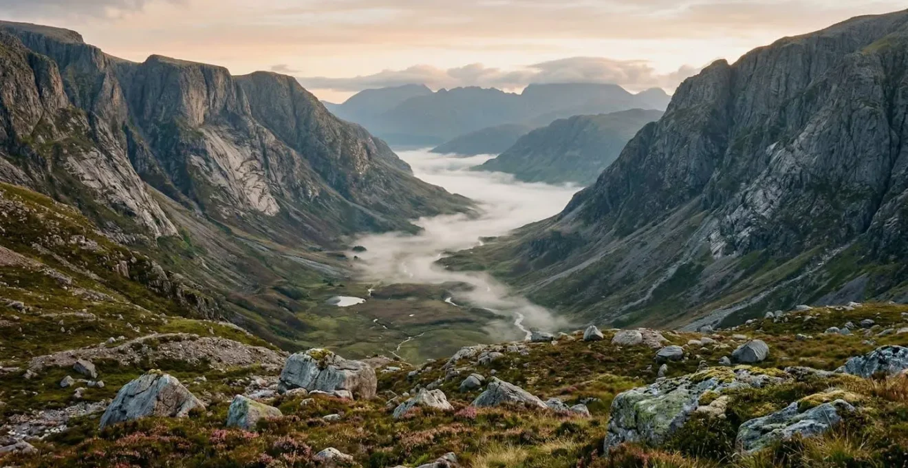
Photographing the Scottish Highlands in the magical, low light of dawn and dusk is a quest to capture not just a view, but the very soul of the landscape. The key to creating powerful, grain-free images lies in using the glacial geography itself as your primary compositional tool. The shapes carved by ice are natural funnels for light and shadow, and understanding them allows you to create images with depth, drama, and atmosphere. Instead of fighting the low light, you can use the landforms to harness it.
As NatureScot explains, powerful ice streams carved deep glacial troughs and rock basins. These features are a gift to the photographer. Morning mist often settles in the base of U-shaped valleys, creating a beautiful low-lying layer of atmosphere that separates the foreground from the distant peaks. The low-angle light of the “golden hour” rakes across the landscape, picking out the texture of glacial moraines in the foreground and throwing the deep, scooped-out bowls of corries into dramatic shadow. This contrast between light and shadow is what creates a sense of three-dimensionality and power.
To achieve clean, grain-free shots, the technical approach is to use a sturdy tripod, a low ISO setting (e.g., 100 or 200), and a longer exposure time. But the artistry comes from geological knowledge. Here are some ways to use glacial geography for more dramatic compositions:
- Position yourself at the mouth of a U-shaped valley to use its leading lines to draw the eye towards peaks illuminated by the rising or setting sun.
- Use a low, side-lighting angle to emphasize the depth of a corrie through the stark contrast between its sunlit rim and its shadowed interior.
- Incorporate the rough, hummocky texture of a glacial moraine in your foreground; its irregular surfaces catch low light beautifully, adding depth and a sense of scale.
- Frame jagged arêtes (sharp ridges between two corries) as high-contrast silhouettes against the soft colours of the twilight sky.
Now, go out into the hills. Armed with this new way of seeing, you are ready to read the epic story that the Scottish landscape is waiting to tell you. Every rock, every slope, and every shadow holds a piece of the narrative.